ABOUT US
Promann Aerial Solutions is paving the way for the future of technology use in Vineyards and Agriculture.
As a company we want to be a sustainable and economic option for Vineyards to incorporate precision viticulture and Crop Growers to promote healthy plants and good quality crops. To achieve this, we use a multispectral camera mounted to a UAV to photograph and analyse a crop or grapevine block for a multitude of different needs that promote healthy growth within the plants such as water stress, early disease detection, fertiliser mapping and vine counts. As well as our interest in precision viticulture, we utilise our skills for other jobs such as construction progress reports, promotional landscape photography, stockpile quantity reports and roof or hard to access inspections
HOW DOES DRONE MONITORING WORK?
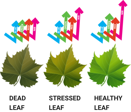
What is a ndvi map
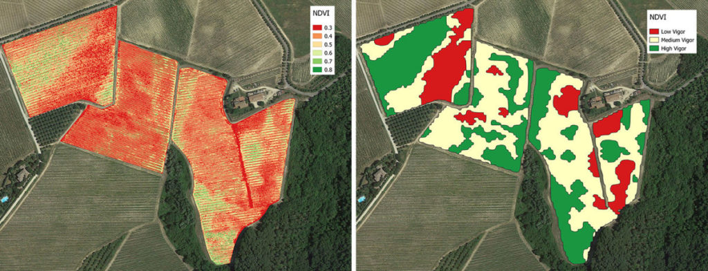
NDVI is calculated from the visible and near-infrared light reflected by vegetation. Healthy vegetation (left) absorbs most of the visible light that hits it, and reflects a large portion of the near-infrared light. Unhealthy or sparse vegetation (right) reflects more visible light and less near-infrared light. The multispectral camera detects the different light reflecting from the vegetation. Once the information is processed, A map can be created showing exactly where different areas of plant health are located. This information can be used to find a host of information like disease stress, water/nutrition deficiencies or powdery mildew flag shoots. This analysis can be used with any plant, grass, crop or tree.
OUR GEAR
Promann Aerial Solutions use the leading edge monitoring drones, sensors and mapping software to ensure the best possible data. This empowers growers to make the well informed decisions and set them on the path to better results from their vineyards or crops.
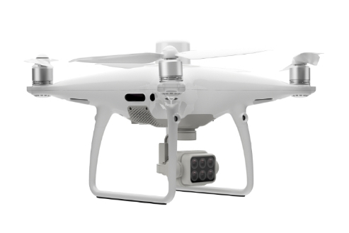
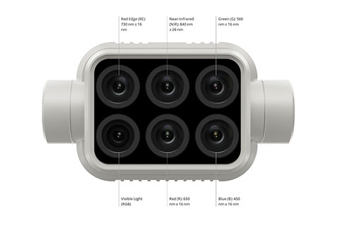
The Phantom 4 Multispectral
The Phantom 4 uses six sensors covering Visible Light, Red, Green, Blue, Red-Edge and Near Infrared to create NDVI maps to assist with any plant health mapping. With the assistance of the DJI software we can plan out the flight path prior to the day to give us an estimate time for the mission. After capturing the data we can run this through a wide array of equations to show Plant health, water stress and more. This allows Viticulturists and Agriculturists an insight into the entire crops quality and what areas need to be focused on more than others.
The Phantom 4 uses a spectral sunlight sensor to maximise its accuracy by capturing solar irradiance, this keeps the data collected consistent through various times of the day to create the most accurate map. With RTK equipped The Phantom 4 has an accuracy of only 1cm difference horizontally and 1.5cm vertically, which allows for the greatest accuracy. With the size of the phantom this makes it the perfect drone to be portable and easily transported between job sites.